
![]()
Ranging - Part 3

What is Ranging?
Ranging is a technique useful in all types of boating to determine whether you are sailing a straight course over ground or are being pushed one way or another (by leeway or current). It is also useful to tell you whether your current course will allow you to clear an object (get through the gap in the Berkeley Pier, say).
The basics are described in Part 1, which describes how to use it crossing a channel with current to maintain a straight course across. Part 2 shows ranging to determine whether you can clear an object.
Another Use
You can also use it in certain cases to determine your position. I’ll give three examples which are useful to Club members, relating to Junior and Senior Dinghy area boundaries. This series of blogs was inspiried by a question from a fellow Senior about how to determine whether we were in the Senior Dingy area.
This post is a bit long, but it’s just several useful (I hope) examples of how to use this in practice.
Am I in the Junior Area?
This is the Junior area (from the Club ORs)
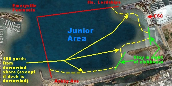
Everyone knows the west boundary as a line from the old restaurant to the trees on the Emeryville peninsula, and I don’t think anyone has a problem identifying this on the water. When you do that, you’re using a range, a line between these two points, and you’re figuring out which side of that line you’re on. Not hard, right?
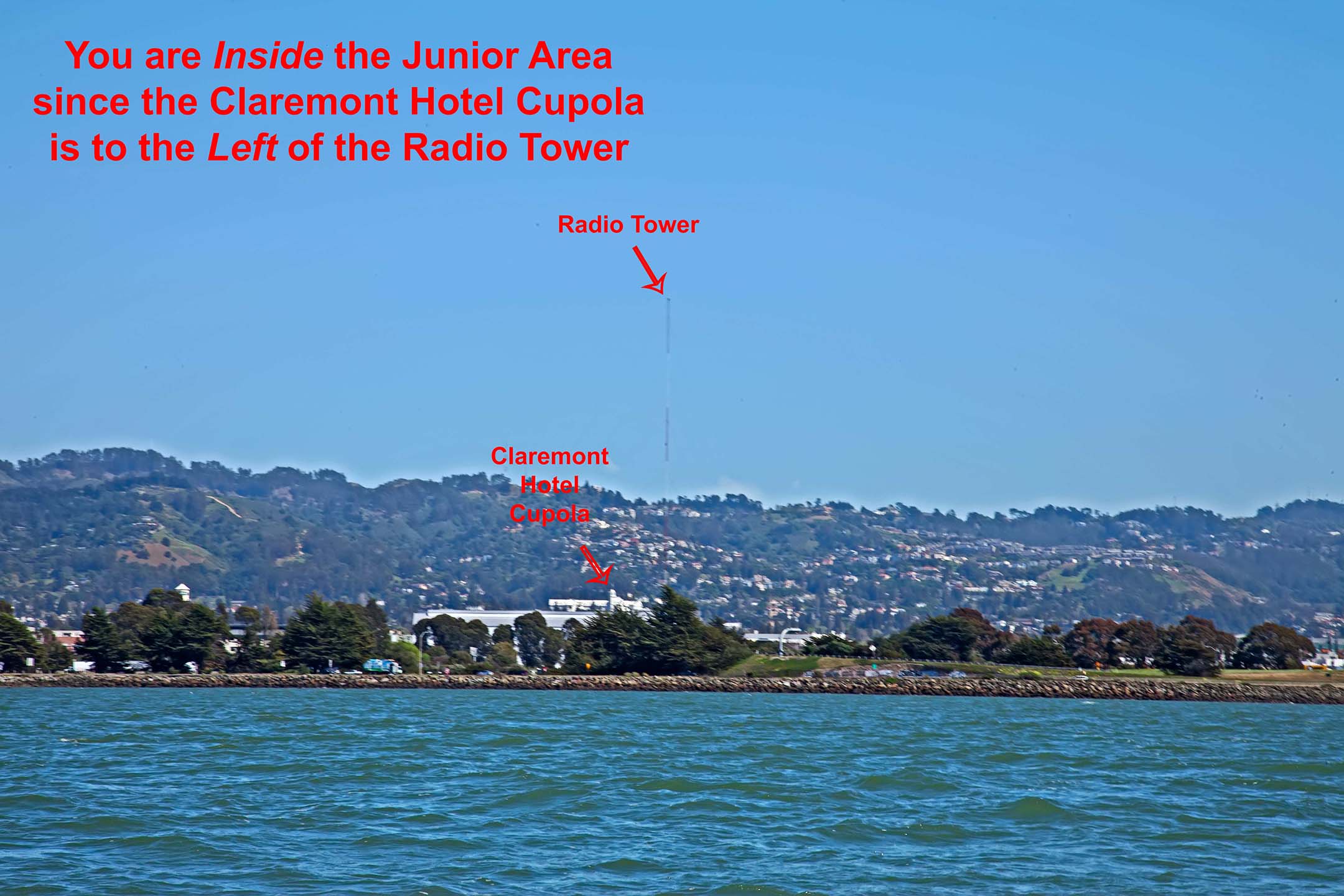
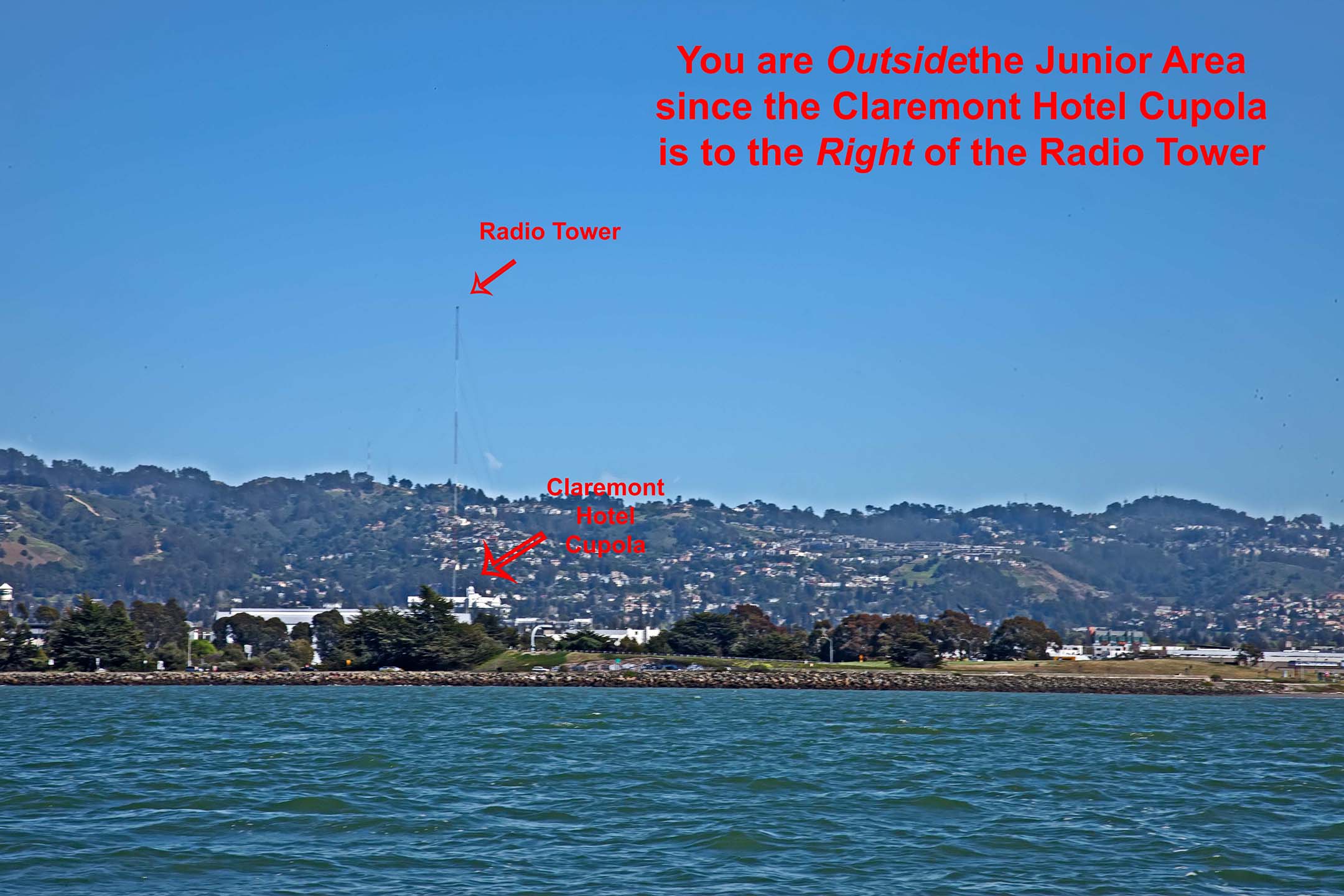
The south boundary requires using a different kind of range. When the cuppola of the Clarement Hotel lines up with the Ashby Ave radio tower, you’re on the line.
If the cuppola is to the left of the tower, you’re still in the Junior area. Note that the radio tower is the closer object here.
If the cuppola is to the right of the tower, expect a visit from the Day Leader.
Here is a summary of what we’ve been doing from above, using a nautical chart:
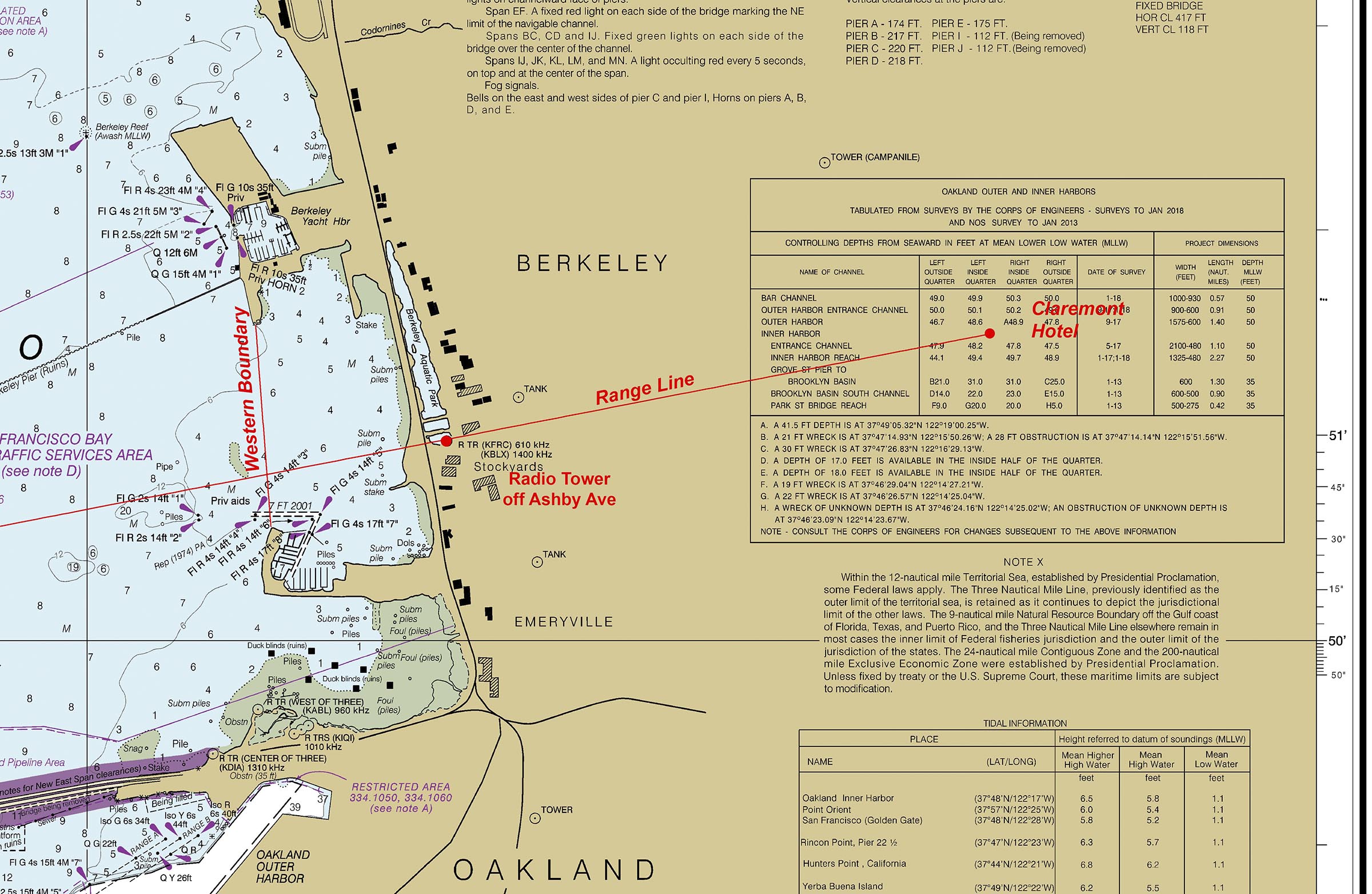
You’ll notice that the Claremont Hotel cuppola is not on the chart, but I can get it’s lat/long coordinates from other sources and put it there.
Am I in the Senior Dinghy Area?
Ranges are useful in answering this question too, but it’s a little more complicated. First let’s look at the Senior Dinghy Area.

There is some text in the ORs about this, but just looking at this diagram, there are some obvious ranges. The easiest one is the south boundary, which is a line from the south point of the Emeryville peninsula to the north end of Treasure Island. The next easiest is a line from the north point of Cesar Chaves Park to the X-Buoy, both shown here in green:
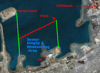
The south boundary is easy, essentially the same technique as the west boundary of the Junior Area, but with different points which are easy to find (the north point of Treasure Island and the south point of the Emeryville peninsula).
Where is X Buoy?
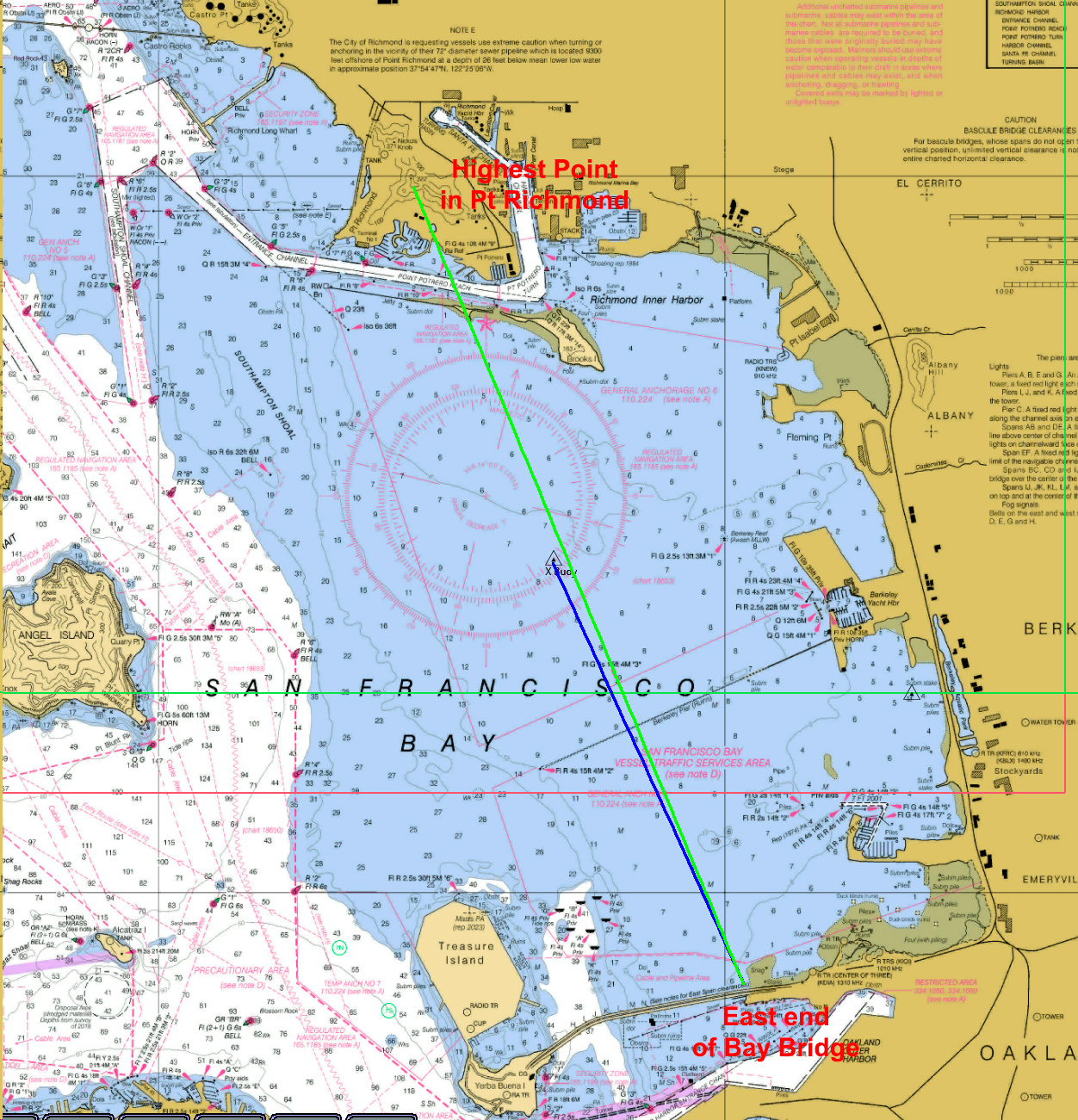
But the north boundary is not so easy. If you’re asking where X Buoy is, you’re in the Olympic Circle, on the north side of the Berkeley Pier. So where is the X Buoy? You won’t see it on most days until you get relatively close to it, maybe 100 yards. How do you find it or know where you are relative to it? Ranges will help you here, as shown in this chart.

This shows that X Buoy is approximately at the intersection of three range lines:
- the west end of Treasure Island to the east end of Brooks Island
- the north end of Cesar Chavez Park to the north end of Angel Island
- the east end of the Bay Bridge (where it connect to land) to the west end of Brooks Island
This is a little more complicated than the others, as you’re looking for the intersection of two of these (two are all you need, just pick the two most convenient ones) and figure out which sides of them you’re on. The third line is probably the least useful, as the east end of Brooks Island is pretty low and hard to see, while the others are very obvious.
And once you figure out where you are relative to X Buoy, you’ll know where you are relative to the north boundary of the Senior Dinghy area.
I’m in the South Basin. Am I in the Senior Area?
This was the original question, and we’ve finally arrived. We can easily determine the south boundary, but the west one is problematic. It’s a line from X Buoy to the east end of the Bay Bridge. The latter is easy to see, but no hope seeing X Buoy on this side of the pier. And the technique we used in the previous example only helps us if we’re somewhere in the neighborhood of X Buoy. So we need something else.
I looked carefully at the chart (a digital one, OpenCPN, but you could do it on a paper one, if you can find one). I plotted the boundary line and extended it looking for a more visible range point than X Buoy, and I found one easily – the highest point in Pt Richmond, which you can see here.
The blue line is the Senior Dinghy boundary line, and the green line is the approximate range line for the Senior Dinghy boundary using the east end of the Bay Bridge and another point very easy to identify, the highest hill peak in Pt Richmond. If I blow up the chart, you’ll see it here.
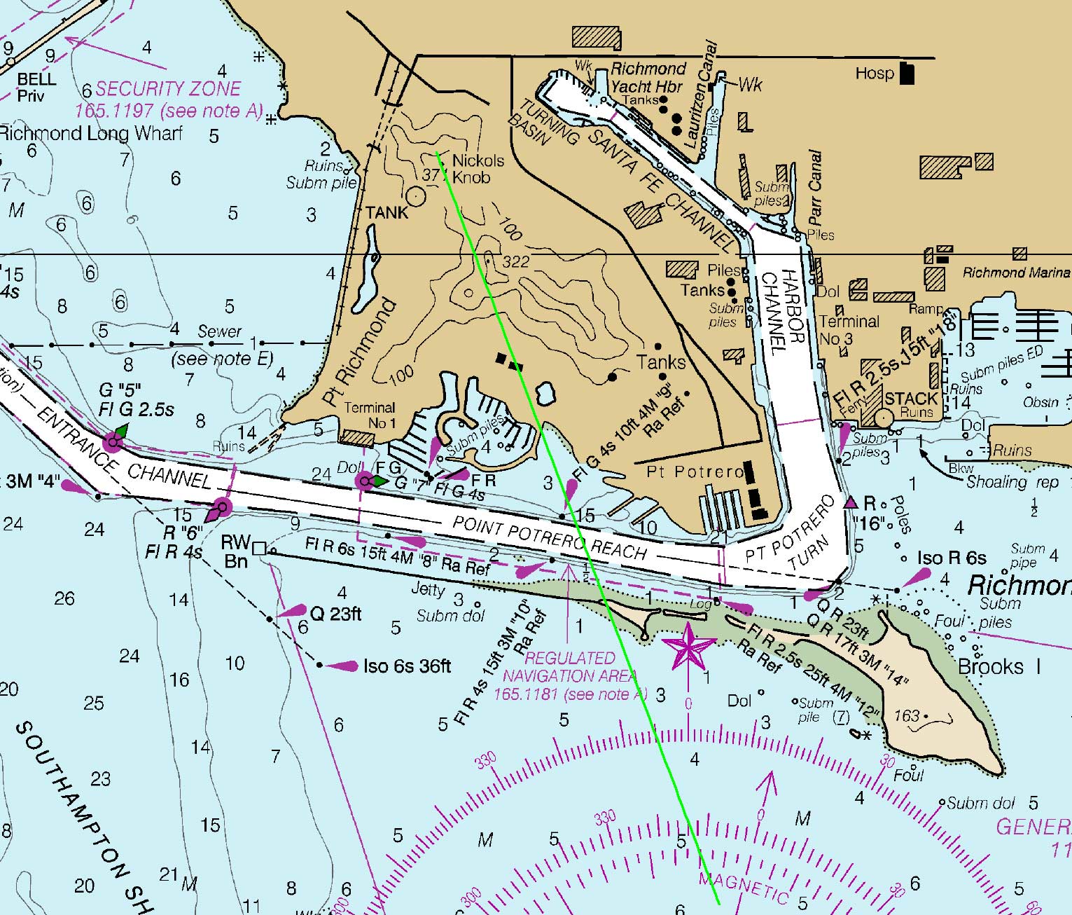
Notice that there are land features on nautical charts, and they are there for this reason. The highest point in Pt Richmond turns out to be a very good range point for this particular problem.
This is what it looks like from the water.
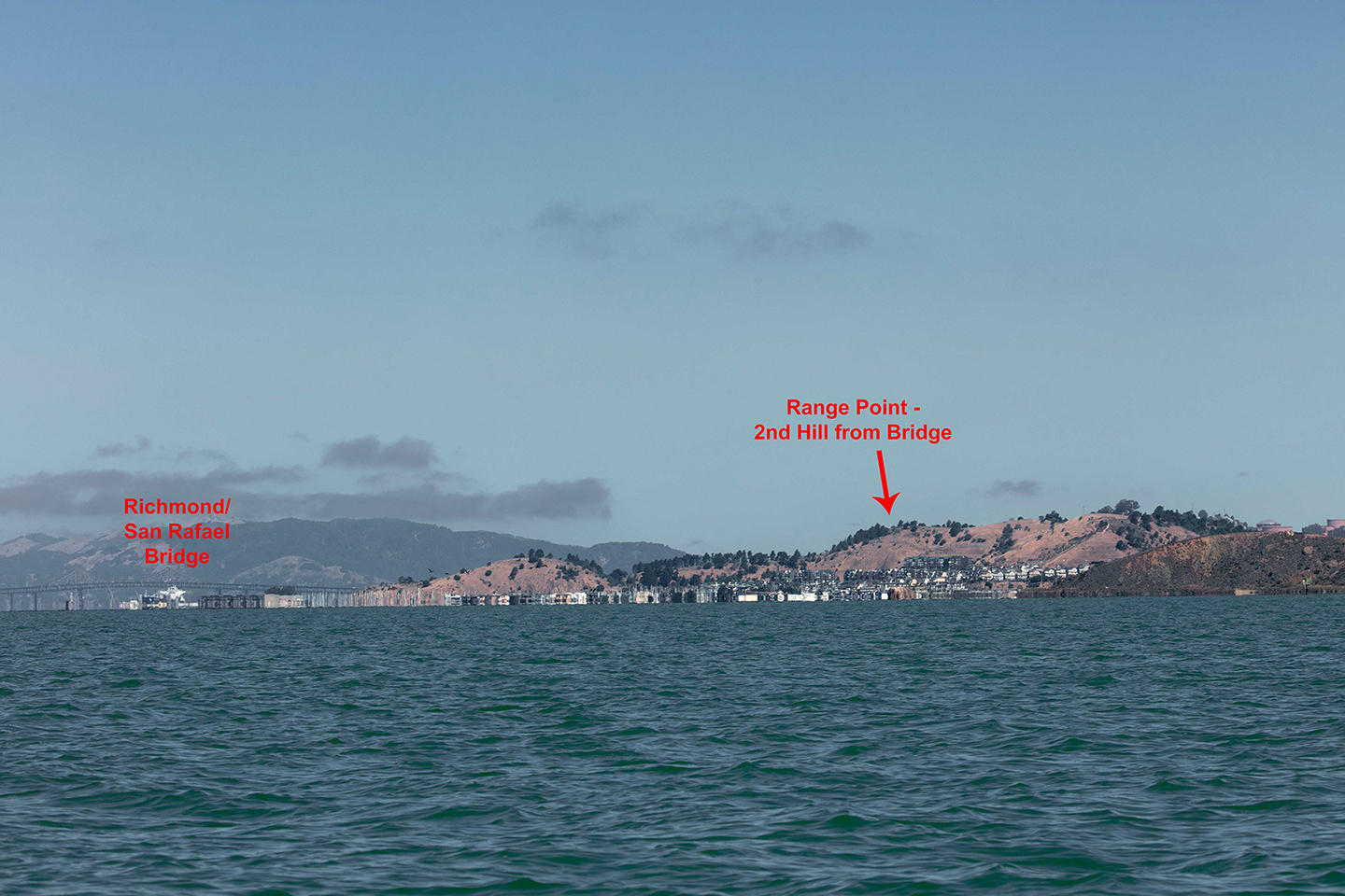
So you’re approximately on the Senior Dingy area boundary line when you see this line up with where the Bay Bridge hits land on the east.
I’ll finish with a quote from James Clarkson when we were trying to figure out how to define the Senior Dinghy Area when X buoy disappeared a few years ago (it’s back now)
It doesn’t matter. If you capsize, you’ll be blown back into the Senior Dingy Area before anyone finds out.
Figuriamoci (go figure).
Up Next
We've seen how to use ranging to determine your course over ground relative to a destination or possibly an object you want to avoid and how to use it in some cases to dermine your position. A variant of this technique is very useful in determining whether you're on a collision course with another boat. I'll explain how to do this based on how you doit with radar.
When you subscribe to the blog, we will send you an e-mail when there are new updates on the site so you wouldn't miss them.
Comments